Using Maps for Genealogy Research, Part 1: Finding Records
Genealogists seek records that describe names, places, and dates. Maps describe places and their names at a given point in time and, sometimes, even record the names of people. Unsurprisingly, then, maps are very useful tools for genealogists.
The New York Public Library Lionel Pincus and Princess Firyal Map Division is home to 433,000 sheet maps, and 20,000 books and atlases published between the 16th and 21st centuries. The collections range in scale from global to local, and support the learning and research needs of a wide variety of users. This post, Finding Records, is the first of a five-part series that describes some of the ways those maps can be used for genealogical research.
- Finding records
- Fire insurance maps: exploring place and time
- Place of origin and immigration stories
- Topographical maps, and county maps and atlases
- Gazetteers and finding maps at The New York Public Library
Identifying where our ancestors lived
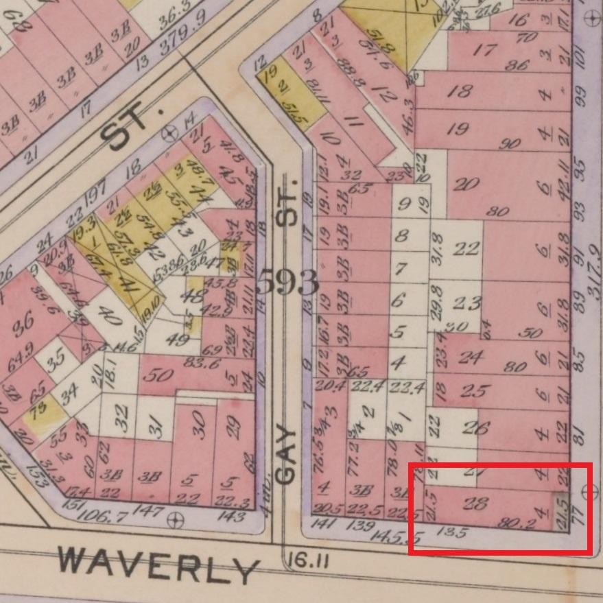
Plate 35, Part of Section 2, Atlas of the city of New York, Borough of Manhattan / G.W. Bromley, 1899
Historical maps can show us where our ancestors lived at a particular point in time. Locating a correct historical address helps researchers find information about people, and a map can confirm that a place existed and can verify information found in other records.
For instance, a plate from a fire insurance map updated to 1902 describes the location of 135 Waverly Place in Greenwich Village, New York, home to one Carsten Gerken, a liquor dealer who had his business on the ground floor of the building, entrance at 77 Sixth Avenue. This address is confirmed by the 1900 census, city directories, and newspapers.
We can see that 135 Waverly Place is on the corner of Sixth Avenue, useful when searching the census by address, looking for historical photographs of a building, or researching a building's history.
Identifying changed street names and building numbers
Why is this important? Well, in a place like New York City, street names and building numbers change all the time. That building located at 77 Sixth Avenue in 1853 is not the same building there now, which was built in 1877—and, by 1953, it's identified as 385 Avenue of the Americas. There's also a change in the spelling of "Waverly."
When searching for our ancestors in a particular place, researchers have to be certain they have the right location.The address 77 Sixth Avenue, the Avenue of the Americas, if it existed, would now be 13 blocks to the south, on the corner of Canal Street—not the place to go looking for records of the life of liquor dealer, Carsten Gerken.

Plate 59, Maps of the city of New-York.
[Perris & Browne], 1857-62

Plate 35, Manhattan land book of the city of New York. G. W. Bromley, 1955
Recording changed political boundaries
A town may be part of a particular county one year, and part of another the next, as county boundaries are redrawn, renamed, or abolished due to annexation. Researchers can use maps to work out exactly which county a town was in at a given point in time.
Records of interest to genealogists—birth, marriage, and death records, or wills and deeds, for instance—are often kept at the county level. To find those records, it helps if one knows where and in what jurisdiction your ancestor’s life events occurred.
For instance, Elmira, the county seat of Chemung County, New York, shown in the 1888 map below, was originally named Newtown, part of Tioga County, as described in the map below, from 1833. But Chemung County was then formed from a part of Tioga County in 1836. Knowing this impacts where genealogists go to look for records created in Elmira: are they in the Tioga County clerk’s office, or the Chemung County clerk’s office?
Hypothetically, an individual could live all their life in the same town but have records of their birth, marriage, and death recorded in three different counties. Historical maps help researchers find those records.
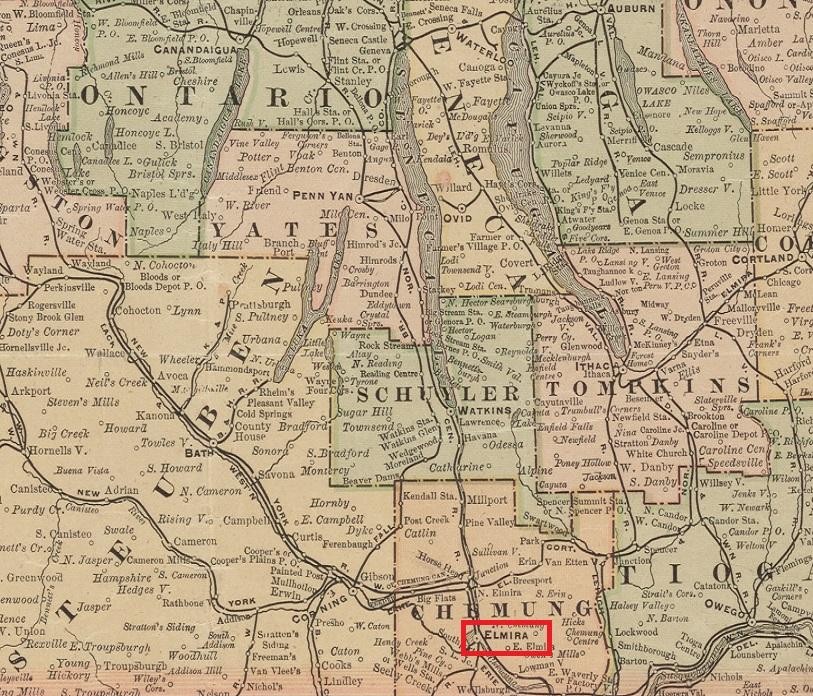
Elmira, Chemung Co., New York, 1888
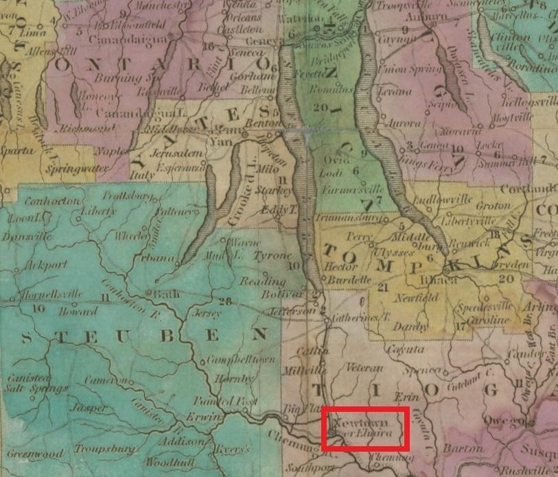
Newtown or Elmira, Tioga Co., New York, 1833
Finding records
Here's another instance in which genealogists use maps to help them locate records: A map of the local boundaries of the Protestant Episcopal Churches of the City of New York (1850) describes parishes and churches, clues that may lead to the discovery of records describing baptisms, marriages, or burials. Helping genealogists find records associated with a house of worship is something that librarians assist with daily at the NYPL Irma and Paul Milstein Division of United States History, Local History and Genealogy.

Plate 33: Maps of the city of New-York, 1857-1862 [detail]
Plate 33 of Perris and Brown's Maps of the city of New-York of 1857 describes several churches and cemeteries on the Lower East Side. Maps record physical changes as buildings come and go, and they also chart changing demographics. A neighborhood populated by parishioners of the Dutch Reformed Church one year may be Episcopalian, Roman Catholic, or Jewish a few years later.
Congregations move from place to place. The Presbyterian church shown in the bottom right-hand corner of Plate 33 was founded as the Stanton Street Reformed Church in 1843, became the Stanton Street Presbyterian Church in 1849, and was consecrated as a synagogue in 1860 (New York Times, 8/8/1860, p.2). The New York City Organ Project is a site dedicated to recording the installation of organs in the five boroughs, and includes invaluable information about the movement of congregations (and their organs).
In 1851, a city ordinance banned new burials south of 86th Street in Manhattan. Eventually, thousands of bodies were removed from Manhattan cemeteries and brought to cemeteries in Queens and Brooklyn. Determining the location of bodies of ancestors once interred in Manhattan is another geneaology exercise that librarians in the Milstein Division can also assist with, and historical maps help researchers find those burial sites.
Hooker's new pocket plan of the city of New York / compiled & surveyed by William Hooker, A.C.S.A., hydrographer & engraver, 1824. NYPL Digital Collections, Image ID: 489850
Hooker’s 1824 Pocket Plan of the City of New York describes the city’s wards, streets, and cross streets. Originally designed to help visitors find their way around the city, Hooker’s map can be now be used in conjunction with records that describe addresses, like a city directory, to explore census records that describe only wards but not streets.
For instance, if an individual is recorded in a city directory as living on Spring Street, we can use Hooker's map to see what ward that address may have been in at a particular census time, or to locate records of the individual’s property taxes. The map describes the names of historical landmarks like the fortress Castle Clinton, Bowling Green, the hospital Belle Vue, and numerous long-forgotten theatres and museums. This information provides color and context to our family histories, and opens up further avenues of research into the Library’s collections.
In addition to a directory of government offices, schools, libraries, hospitals, newspapers, and so on, Hooker's map also includes "Places of Public Worship," "Public Buildings in the Park," and "Daily Public Journals." Here's a sample of records, transcriptions of records, and digitized historical newspapers at the NYPL that are identified by name in the map:

"Places of Public Worship"
Records of Christ Protestant Episcopal Church in New York City, N.Y. / Edited by Royden Woodward Vosburgh. NYGB AZ+ Loc 09686
Ancestry Library Edition, U.S., Dutch Reformed Church Records in Selected States, 1639-1989: New York: New York City
Methodist Episcopal Church records 1791-1945 MssCol 1978 & Ancestry Library Edition (onsite)
"Daily Public Journals"
American, Evening Post, Commercial Advertiser, National Advocate, Statesman:America’s Historical Newspapers
Mercantile Advertiser, Daily Advertiser, Gazette *ZY [microfilm]
"Public Buildings in the Park"
Naturalizations in the Marine Court, New York City, 1827-1835 / abstracted by Kenneth Scott.
Index of the letters of administration filed in New York County from 1743-1875 / Gertrude Barber
Original will libers in the Surrogate’s Office [New York County] [microform]
Abstract of wills, probated in the Common Pleas Court, also known as Mayor's Court, 1819-1892 [...] New York County, New York City, N.Y. / Ray C. Sawyer.
Finding photographs
NYPL local history collections include tens of thousands of historical photographs of streets and buildings—many no longer standing—of New York City, images served through NYPL Digital Collections. Genealogists can use fire insurance maps to identify the homes of their ancestors in photographs. For instance, a researcher wants to know where Benjamin Britt lived in New York City in 1920 and, if possible, what the building looked like. Using a digitized 1920 New York city directory to find an address, 344 West End Avenue, and a fire insurance map to pinpoint not only the location but also the shape and layout of the building, a researcher is able to find a picture of Benjamin Britt’s home from approximately the period he would have lived there.

Clockwise: Britt, Benjamin, from Trow's New York City Directory, 1920-21; Plate 6 Atlas of the city of New York, borough of Manhattan / George W. and Walter S. Bromley 1920; Manhattan: West End Avenue - 76th Street West 1925
More maps that help researchers find records
Pretty much any map can be used to locate genealogical data. Some other maps in the NYPL collections that help researchers find records describing familial relations include:
- Land auction maps, described in Absolute Sale! NYC Land Auction Catalogs in the Map Division.
- Census maps, more on those in Genealogy Tips: Searching the Census By Address.
- The snappily titled Maps of farms commonly called the Blue book, 1815 : drawn from the original on file in the street commissioner's office in the City of New York, together with lines of streets and avenues / laid out by John Randel, jr., 1819-20 identifies the locations and boundaries of farm land and estates, and the owners of those properties, at a time preceeding the Manhattan grid.
- Maps of cemeteries, like Green-Wood Cemetery, Woodlawn Cemetery, Albany Rural Cemetery, Tarrytown Cemetery at Sleepy Hollow, West-Chester County, N.Y., and many more.
Next, Part 2: Fire insurance maps: exploring space and time.