Using Maps for Genealogy Research, Part 3: Place of Origin and Immigration Stories
Genealogists seek records that describe names, places, and dates. Maps describe places and their names at a given point in time and, sometimes, even record the names of people. Unsurprisingly, then, maps are very useful tools for genealogists.
The New York Public Library Lionel Pincus and Princess Firyal Map Division is home to 433,000 sheet maps, and 20,000 books and atlases published between the 16th and 21st centuries. The collections range in scale from global to local, and support the learning and research needs of a wide variety of users. This post, Place of Origin and Immigration Stories, is the third of a five-part series that describes some of the ways maps can be used for genealogical research.
- Finding records
- Fire insurance maps: exploring place and time
- Place of origin and immigration stories
- Topographical maps, and county maps and atlases
- Gazetteers and finding maps at The New York Public Library
Here, we look at maps that record our ancestors' place of origin, and that chart immigration to the United States. We'll also look at how maps might be used to illustrate an immigration story.
Place of Origin
The Library’s map collection is international in scope. Searching the collections, researchers will find maps that show where their ancestors originally came from. These maps represent the places of origin for some of the major groups of peoples to come to this country. Many people researching their family history are ultimately hoping to make a connection to a place of origin. How easy this is often depends on the records available. Were births, marriages, and deaths recorded? Were there censuses? If so, did those records survive? Maps are a powerful tool when it comes to learning about place of origin.
"A new map of that part of Africa called the coast of Guinea from the River Senegal in Latt. 16d. No. to Cape Lopez 1d. 00' So. with the Inland Countries from the sea so far as the great rivers Senegal and Niger." NYPL Digital Collections, Image ID: ps_rb
For instance, of the 900,000 people who arrived in the United States by 1790, 360,000 were forced immigrants from Africa. Most slaves came from countries in West Africa, from modern-day Senegal and The Gambia. This 1734 map of West Africa during the slave trade shows the principal towns and ports and is an important link to the place of origin for so many Americans.
"Map of Europe according to the newest and most exact observations ...1736"; NYPL Digital Collections, Image ID: 1630431
Up until the 1880s, the largest groups of immigrants to the United States came from Germany, Ireland, and Great Britain, though significant numbers came from Scandinavian, and other Northern and Western European countries. Those places are represented in historical maps in NYPL collections.
"Carte Nouvelle des Royaumes de Galizie et Lodomerie, avec le District de Bukowine." NYPL Digital Collections, Image ID: 3937526
From the 1880s to the 1920s, most migrants came from Southern and Eastern Europe, Southern Italy, Poland, Austria-Hungary, and Russia. Many Russian Jews immigrating to the United States came from Galicia, described here on a map from 1701, a region that straddled modern-day Poland and Ukraine. Galicia, like the Pale of Settlement, is a region not usually described on modern maps.
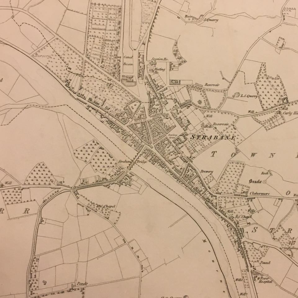
Strabane [clipping] sheet 5, volume 31, Tyrone, from Townland survey of the counties of Ireland : maps published on the scale of six inches to a mile / engraved at the Ordnance Survey office, 1832-1911
A Civil War veteran, Bernard Trainor (1816-1868) lived in New York City, where he enlisted in the 69th Infantry regiment, NY, perhaps better known as the Fighting Irish. An abstract from the 69th muster roll records his place of birth as Strabane, Co. Tyrone, Ireland.
In Ireland, very few census records for the 19th century survive. In the absence of written records, a detailed map helps fill the gap in the story of Bernard Trainor's life. The clipping shown, from volume 31, sheet 5 of the Townland survey of the counties of Ireland: maps published on the scale of six inches to a mile / engraved at the Ordnance Survey office (1832-1911) describes Strabane around the time the veteran would have left for the United States, and is a vivid link to his place of origin.
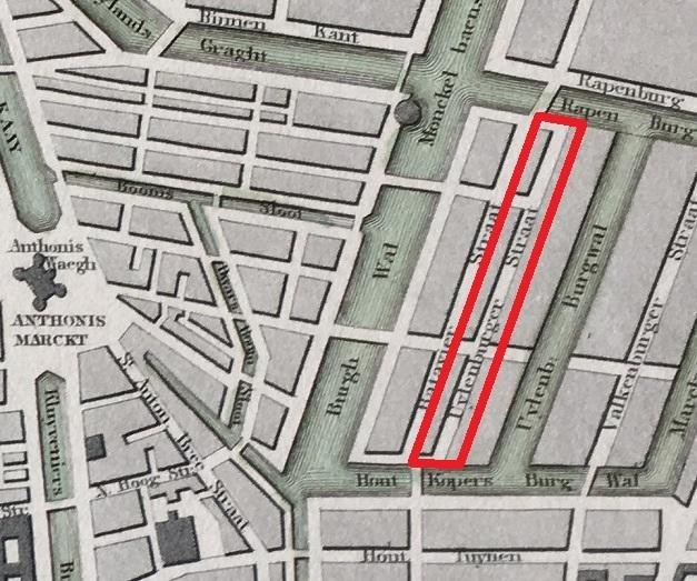
Map of Amsterdam [detail], W.B. Clarke, 1850.
W.B. Clarke’s Map of Amsterdam describes the city in 1850. This is a good example of a map that works well with a census record, in this case the Amsterdam Civil Register of 1851-3. The register lists widower Moses Hamel, born 1814, and his children: Israel, born 1842; Betje, born 1844; Jacob, born 1846; and Naatje, born 1851. They live on Uilenburgerstraat, in the Jewish Quarter of Amsterdam known in Dutch as the Jodenbuurt, and we see the street in Clarke’s map.
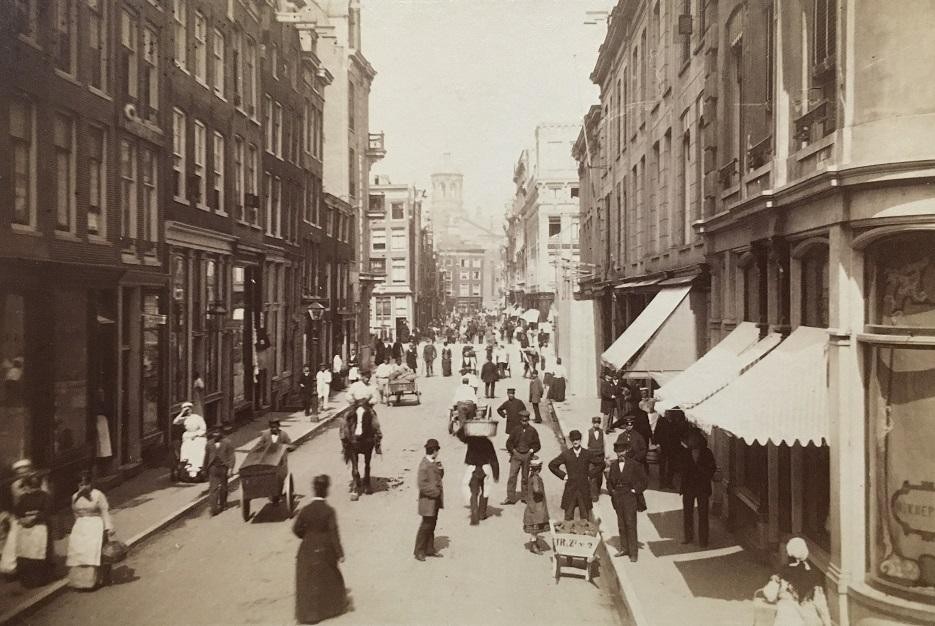
Amsterdam in the1800s; NYPL Picture Collection
During the Nazi occupation of Amsterdam during World War II, most Jewish residents of the city were removed from their homes and sent to concentration camps. Of the 80,000 people who lived in the city before the war, only 5,000 were living at the time of liberation in 1945. Many of the buildings in the Jodenburt were abandoned and became derelict, swept away during the re-development of Amsterdam in the mid 1970s, so now the area is very different. Clarke’s map survives as one record of the Jewish quarter in Amsterdam before the Holocaust.
Journeys
NYPL map collections describe immigration to the United States, and the routes and methods of transport our ancestors took to get to where they settled. There are maps that describe transatlantic shipping routes, cross-country trails and wagon routes, canals, railroads, roads built for automobiles, and airline flight paths. There are maps of the Underground Railroad, maps that chart the Great Migrations of African-Americans in the 20th century, travellers' guides, maps that record immigration, and maps designed to encourage immigration.
"Underground" routes to Canada showing the lines of travel of fugitive slaves, extracted from The Underground Railroad from slavery to freedom, William Henry Seibert,1898. NYPL Digital Collections, Image ID: 5365491
An Immigration Story
Stories about our ancestors come alive when illustrated with maps, photographs, and contemporary historical source materials to create narratives that engage with the reader.
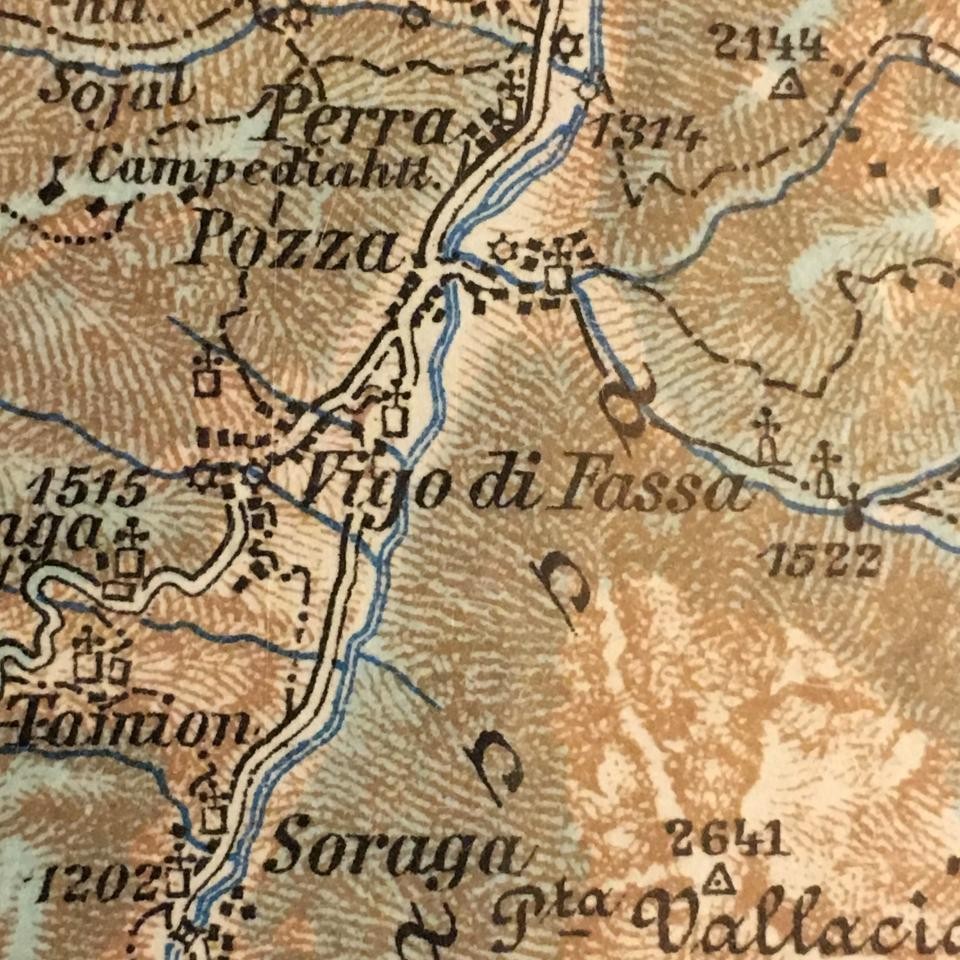
Vigo di Fasso: Trient 29:46, K.u.K. Militärgeographisches Institut, 1918
For instance, let’s take an oral history from Passages to America : oral histories of child immigrants from Ellis Island and Angel Island by Emmy E. Werner and illustrate what is already a fascinating story with maps, photographs, and other documents available from collections at the Library and elsewhere.
In 1920, Marion Da Ronca, age 9, came to the United States from Vigo in Northern Italy with his mother Regina, 50, and his older sisters, Giovanna, 23, and Lina, 15. They were going to stay with Marion's oldest sister, Lena Gotta, who lived with her husband and their children in Iron Belt, Wisconsin.
Immigrants Traveling In A Horse Driven Cart; NYPL Digital Collections, Image ID: 805476
The journey took approximately 15 days by horse-drawn carriage, four steam trains, two ferries, one ocean liner, and at least one bus. Marion described his journey in an interview conducted in 1992:
"The only thing we packed was our clothes. That’s all there was to pack. We travelled ten to fifteen miles on a horse-drawn carriage, then boarded a train to Padua [...] in Italy.[...] Then we boarded a train to Cherbourg, France."
The map included here, drawn by the U.S. Army Map Service in 1943, gives the viewer an idea what Cherbourg Harbour may have been like in 1921. The railroad line runs right down to the quayside, where ferry boats are waiting to take passengers to their steamship. Marion describes this:
![Town Plan of Cherbourg / U.S. Army Map Service, 1943 [detail]](/scout/_next/image?url=https%3A%2F%2Fdrupal.nypl.org%2Fsites-drupal%2Fdefault%2Ffiles%2Fstyles%2Fmax_width_960%2Fpublic%2Fblogs%2Fcherbourg1941.jpg%3Fitok%3DiJ1Wem--&w=3840&q=90)
Town Plan of Cherbourg / U.S. Army Map Service, 1943
"The following evening the tide came in and they ferried us to the boat."
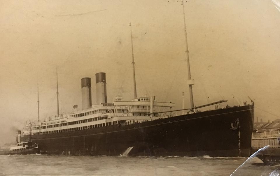
R.M.S. Adriatic / NYPL Picture Collection
That boat was the RMS Adriatic, a steam passenger ship of the White Star Line, launched in 1907. It sailed from Southampton, England, to New York City, picking up passengers up at Cherbourg. The ship weighed 25,000 tons and held 2,825 passengers—1,900 in steerage, where Marion and his family would have been.
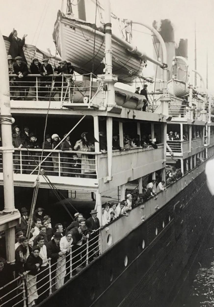
A 1921 deck scene on the R.M.S. Adriatic / NYPL Picture Collection
The NYPL Picture Collection features thousands of images of sail and steam passenger ships not available online, including photographs of the R.M.S. Adriatic shown in this post. Marion and his family are described in the manifest below: note that Marion's mother is traveling under her maiden name, Martini, something married Italian women commonly did at this time.
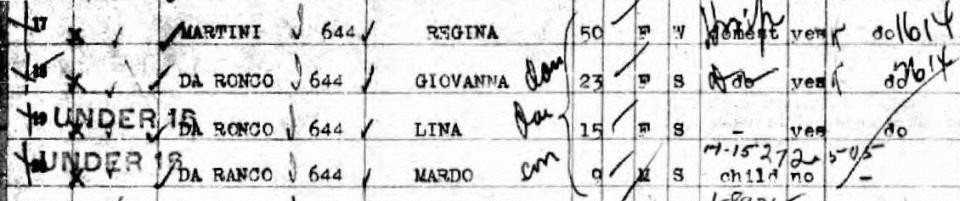
New York Passenger and Crew Lists, 1820-1957: Regina Martini, June 25, 1920
Marion describes the journey, his family suffering from seasickness, venturing out onto the third-class deck, and watching dolphins swim behind the ship. After nine days, the R.M.S. Adriatic arrives at the Port of New York.
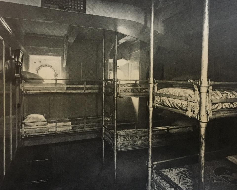
Third Class Cabin / NYPL Picture Collection
"As we entered the harbor in New York, I saw the Statue of Liberty. We stood on the side of the ship, and my mother told me, 'Remember her. For years to come, you will be thinking about her.' And she was right. Everyone stood up and took their hats off when she went by."
Statue of Liberty; NYPL Digital Collections, Image ID: 118794
Many researchers wonder how their ancestors got to and from the immigration receiving station at Ellis Island once they had arrived at the Port of New York. Did steamships dock at Ellis Island? Or did ferries take immigrants there? How did immigrants get back to the mainland? And then on to their final destination?
Hagstrom's Map of Lower New York City, House Number and Subway Guide of 1920 identifies the names of the piers where the ocean liners of the various steamship companies docked, carriers like the White Star Line, Cunard, and the Hamburg-Amerikka Line (as shown). It also describes the routes of the ferries to and from Ellis Island (as shown), the locations of subways and trams that would take immigrants to relatives or to their new homes in Manhattan, Brooklyn, or New Jersey, for instance, and the location of railroad stations that would have transported passengers all over the United States.
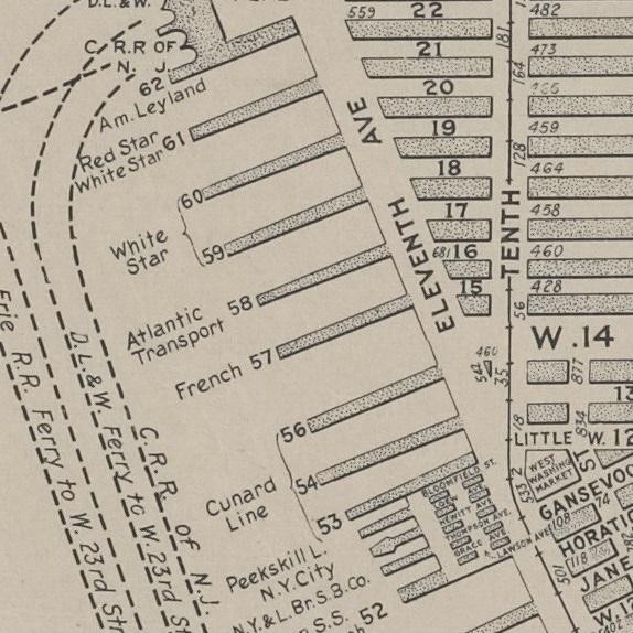
Hagstrom's Map of lower New York City, House Number and Subway Guide, 1920
Hagstrom's Map of lower New York City, House Number and Subway Guide, 1920: detail showing Ellis Island
Marion's story continues…"And the tugboats were waiting for us. They pulled alongside, and they pushed the boat right into port. Then they ferried us to Ellis Island."
Immigrant Station, Ellis Island, with ferry docked at adjacent pier; NYPL Digital Collections, Image ID: 416752
"We were all examined, and then we stayed overnight."
Immigrants undergoing medical examination; NYPL Digital Collections, Image ID: 416754
"We had four bunk beds. There was one for my mother, one for me, then one for each of my sisters, all in one room. And they were hard, covered with just a couple of blankets."
J.J. Lussier Commissary Contractor: Breakfast at Ellis Island; NYPL Digital Collections, Image ID: 4041474
"We ate in the big dining room. My mother held me by the hand all the while. She never let go as long as we were there."
Dining hall on Ellis Island; NYPL Digital Collections, Image ID: 416771
"When we left Ellis Island, we went back to the ferry and then took a train out from New York City to Detroit."
Penn Station, Interior, Manhattan / Berenice Abbott; NYPL Digital Collections, Image ID: 482700
"We changed trains in Detroit and went to Chicago. In Chicago, they bussed us around the lake to the Northwestern Station…"
First double-deck coach for Chicago. Model Z-67-Pass. 1923; NYPL Digital Collections, Image ID: 482074
"… and from there we went to Hurley, Wisconsin. We stayed over at my sister’s. I went to school the following fall, and in about five to six months I was talking pretty good English."
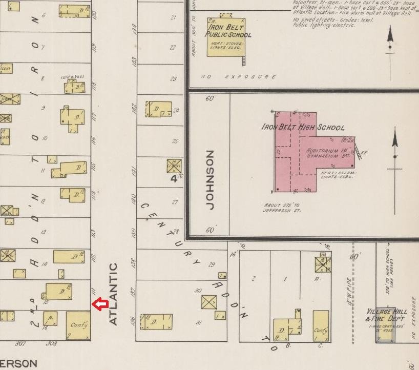
Plate 11 of Sanborn Fire Insurance Map from Hurley, Iron County, Wisconsin, 1922.
The map featured, Plate 11 of the Sanborn Map of Hurley, Iron County, Wisconsin, published in 1922, describes the final destination of Marion and his family, the home of his Aunt Lena. Inset on the plate are two schools, possibly including the school that Marion attended.
Previous, Part 2: Fire Insurance Maps: Exploring Space and Time
Next, Part 4: Topographical Maps, and County Maps and Atlases