Using Maps for Genealogy Research, Part 5: Gazetteers and Finding Maps
Genealogists seek records that describe names, places, and dates. Maps describe places and their names at a given point in time and, sometimes, even record the names of people. Unsurprisingly, then, maps are very useful tools for genealogists.
The New York Public Library Lionel Pincus and Princess Firyal Map Division is home to 433,000 sheet maps, and 20,000 books and atlases published between the 16th and 21st centuries. The collections range in scale from global to local, and support the learning and research needs of a wide variety of users. This post, Gazetteers and Finding Map, is the last of a five-part series that describes some of the ways maps can be used for genealogical research.
- Finding records
- Fire insurance maps: exploring place and time
- Place of origin and immigration stories
- Topographical maps, and county maps and atlases
- Gazetteers and finding maps at The New York Public Library
In the previous four parts of "Using Maps for Genealogy Research," we have explored places using all sorts of maps: fire insurance maps, historical maps, cadastral maps, topographical maps, route maps, and many more. But what if you don't know the location of the place you're looking for? This post will help answer that question as we look at gazetteers, and then we'll finish up the series with a look at how you go about finding maps at The New York Public Library.
Gazetteers
In its simplest form, a gazetteer is a list, dictionary, or directory of place names and their geographical location, usually their latitude and longitude. More detailed gazetteers may also include information about name changes, boundary changes, histories, demographic information, manufacturing data, the economy, tourism, forms of government, and so on.
A detailed gazetteer may even describe places not identified on most maps, which encourages us to dig a bit deeper and look for a map that records our ancestor’s location. This information helps a researcher find a place on a map when its location is unknown, cannot easily be seen, or is not described. Perhaps that place no longer exists or the scale is too small for it to be shown, especially in the case of a small village or hamlet. Perhaps the place name has changed over the years; even if the name has changed, its geospatial coordinates should be the same.

For instance, the genealogy database Ancestry Library Edition includes a record set, "Belarus and Lithuania: Census and Family Lists from various districts, 1795-1900," that records the Krivis family in Kavarskas, Lithuania between 1892 and 1894. Lithuanian Jews, the Krivis family immigrated to the United States in about 1901, so this is a place of origin for them.Where Once We Walked: A Guide to the Jewish Communities Destroyed in the Holocaust, by Gary Mokotoff and Sallyann Amdur Sack, gives the geospatial coordinates for Kavarskas, 55°26’/24°55’, 88 kilometers NE of a bigger town, Kaunas. This is useful as Kavarskas' population is listed as only 436. In addition to this information, alternate names for Kavarskas are given: Kavarsk, Kovarsk, Kovarskas, and Koverskas.
The JewishGen Communities Database has a Locality page for Kavarskas that includes more name variations in Russian and Yiddish, Коварск and אָוואַרסק. The Locality page gives the Jewish population for Kavarskas in 1897 (979) and a timeline. Before World War One, Kavarskas was known as Kovarsk, and was part of the Russian Empire; between the World Wars, the village was known as Kavarskas and was a part of Lithuania; from 1944, the name remained the same but Kavarskas was part of the Soviet Union until 1990, when Lithuania regained its independence. The Encyclopaedia of Jewish Communities: Lithuania (1996) includes an entry for Kavarskas:
After the German invasion of the Soviet Union on June 22, 1941, Lithuanian nationalists took control of Kavarskas. They entered Jewish homes and plundered whatever came to hand, broke windows, and set fires in Ukmerge street, where the Jews lived [Ukmerge is the Lithuanian name for the town previously known as Vilkomir]. They also arrested 30 Jewish men and women on the pretext that these had sympathized with the Soviet regime. It is most probable that the real reason was personal enmity. After the entry of the Germans into the town, on June 26, 1941, all the prisoners were shot on the banks of the river, near the village of Pumpuciai, to the south of Kavarskas. The situation of the other Jews in the town was desperate, they lived in deadly fear. The Lithuanians insulted, tormented them and robbed their property. Then, later, led them to Ukmerge and murdered them together with other Jews of the town and vicinity, in the Pivonia forest. (Pivonijos miskas). It appears, this event took place on September 5, 1941.There were no survivors from Kavarskas. The names of the Lithuanian murderers are on record in the Yad Vashem archives in Jerusalem.
The Library has in its collections all sorts of gazetteers for New York, the United States, and many countries: Ireland, England, others in Eastern Europe and Africa…you name it. Some of those gazetteers date back hundreds of years and are of particular value to people researching places at different points in history.
For more information on gazetteers, please consult the NYPL Lib Guide Gazetteers and Other Place-Name Resources.
This five-part series has been a brief exploration of some of the ways genealogists can use just a few different types of maps in their research, to find records, illustrate family histories, and open up new avenues of investigation. There are many more maps that describe streets, property auctions, population demographics, and census wards. There are pictorial maps, military maps, pocket maps, relief maps, coastal maps, maps of the oceans, and maps of the stars. Maps of the moon. (And let us not forget globes.) That's just in the collections of The New York Public Library!
Accessing maps
There are a number of ways researchers can access maps from The New York Public Library’s collections.
Search for print maps in the NYPL Classic Catalog and Dictionary catalog of the Map Division (aka G.K. Hall), digitized by the Hathitrust. Better still, come to the Map Division in person and talk to a map librarian about what kind of map might help with your research. You can plan your visit in advance by emailing the Map Division at maps@nypl.org. Tip: Think about what you want to see in that map: continents, countries, states, counties, towns and cities, or streets and houses? This information will help you with your map hunt.

Since 2001, the Library has digitized approximately 25,000 maps, including thousands of plates from fire insurance maps, county maps and atlases, and historic maps of New York City and the United States, all available to view, and often download for free, via NYPL Digital Collections. This guide includes links to NYC Fire Insurance, Topographic and Property Maps.
Search for maps online in the Library’s Digital Collections using the NYPL Map Warper "Find Maps By Location" tab. Designed for rectifying maps, the map warper can be used by genealogists to search for historical addresses; compare places in historical maps with a modern map to see what changes have occurred at a particular place; download digitized maps; and export digital geospatial data for their own use. This handy post has more details: How to Find Old Maps by Location with Map Warper.
Search across Sanborn Maps, New York State (Geocoded) fire insurance maps in the Library, or at home with your NYPL Library card. (Apply for your Library card here.)
Old Maps Online is an Anglo-Swiss project that maps hundreds of thousands of digitized historical online maps all over the world. Users can search for maps from NYPL, the United States Geological Survey, the David Rumsey Map Collection, the British Library Map Library, the Harvard Map Collection, and the Boston Public Library.
Maps By Decade is a tool built by Bert Spaan as part of the NYPL space/time directory digital initiative. Search fire insurance maps that describe a single place across decades in one go, with this tool that links to NYPL Digital Collections, the NYPL Map Warper, and geospatial data.
One last map…
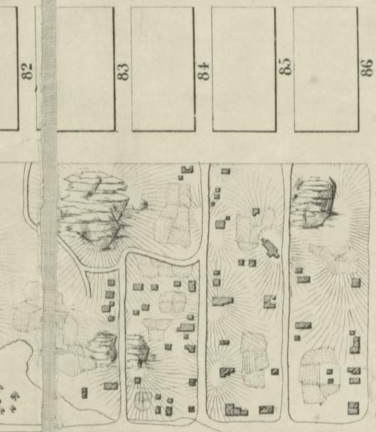
"Map of the lands included in the Central Park, from a topographical survey, June 17th, 1856" / Egbert L. Viele; detail showing Seneca Village
Personally, one of my favorite maps is "Map of the lands included in the Central Park, from a topographical survey, June 17th, 1856," drawn by Egbert L. Viele. If you view the map in NYPL Digital Collections, and zoom in to the area between 82nd and 86th Streets, north of the Receiving Reservoir, you'll see a scattering of buildings, outlines that describe what looks like homes and several churches.
This is a cartographic representation of Seneca Village, a community that lived in an area that became part of Central Park, settled in 1825. It was "Manhattan’s first known community of African Americans [...] numbering more than 250 people, with three churches, several cemeteries, and a school. African Americans owned more than half the households." (Seneca Village from The Encyclopedia of New York City, pp.1167-8).
The community expanded, with Irish and German immigrants, and possibly Native Americans also living there, until the village was razed to make way for Central Park, in 1857. Viele’s map is one of the few visual documents that survives to describe that community, a powerful record of a marginalized community living in New York City. The Seneca Village Project and the New York Parks Department have more information on Seneca Village.
Some further reading
Resources used in the creation of this blog series are, for the most part, described within, but here follows a select reading list:
Walking with your ancestors: A Genealogist's Guide to Using Maps and Geography by Melinda Kashuba (2005)
Using Maps in Genealogy / United States Geological Survey [pdf]
Sanborn Maps / Library of Congress [online]
Maps & Civilization: Cartography in Culture and Society by Norman J.W. Thrower (2007)
The Story of Maps by Lloyd Brown (1949)
A History of the World in Twelve Maps by Jerry Brotton (2013)
Landmarks of Mapmaking; an illustrated survey of maps and mapmakers. Maps chosen and displayed by R. V. Tooley; text written by Charles Bricker; preface by Gerald Roe Crone (1968)
Manhattan in maps, 1527-2014 by Paul E. Cohen and Robert T. Augustyn (2014)