Humanities and Social Sciences Library > Collections & Reading Rooms > Print Collection > MOVING
UPTOWN
Section II (including Erie Canal celebration and
Great Fire)
New York in the Late 1820s and Early 1830s
By the end of the 1820s, the city was solidly built as far as Canal
Street. While some of the richest families continued to live in the exclusive
confines of Bowling Green, shops and hotels were replacing private homes
on Broadway, and by the 1830s, banks, countinghouses, and drygoods companies
had established themselves all the way to Trinity Church. Many well-to-do
residents moved ahead of the "tide" of commerce, north and west of Broadway
to Park Place and St. John's Park, and to Bond, Bleecker, and Lafayette
streets to the north and east. These fashionable areas had their day in
the 1830s and 1840s, but by the early 1850s had begun to decay. The row
houses on Bond, Bleecker, and Lafayette became boardinghouses for immigrants;
in the 1850s and 1860s, tenements were built on the Bowery, and first boardinghouses
and slums, then commerce, encroached upon the refuge of Park Place and
St. John's Park.
Broadway and Bowling Green. About 1826
Attributed to William James Bennett (American, b. England, 1787–1844)
Graphite and ink wash
Print Collection, Frederick and Sandra P. Rose Fund, Wallach Fund and Contributions
to Prints
In the early 19th century, Broadway was considered the most exclusive
address in the city. In 1828, over 100 of the city's 500 richest men lived
on that street, and though many of the houses on lower Broadway were being
transformed into stylish boarding homes, shipping and accounting houses,
and law firms, Bowling Green remained a residential oasis. Even in 1837
the New York Herald reported that Bowling Green was "the only
place in the lower part of the city, whose rural picturesque and placid
beauties still remain, in the midst of the mad mania of speculation and
improvement . . . the quiet air of the old times still lingers. . . ." However,
by 1837, many of the genteel residences had also become boardinghouses.
William James Bennett, a British painter and printmaker recently arrived
in this country, probably sketched this view, a study for the aquatint
below, in 1826, before the gas lights were introduced on Broadway between
the Battery and Grand Street.
Broad Way from the Bowling Green. Probably
1826
William James Bennett (American, b. England, 1787–1844)
Aquatint and etching, from Megarey's Street Views in the City of New York,
published about 1834
The Phelps Stokes Collection
 The landmarks recorded in Bennett's masterful aquatint include, starting
on the left: Kennedy House at No. 1 Broadway, where George Washington lived
during the early days of the Revolution, and later the home of Sir Henry
Clinton, Sir Guy Carleton, and Sir William Howe during the long British
occupation of the city. Washington lived in the large white building two
houses up the block during his first term as President. Further along the
street, in the distance, are the steeples of Trinity and Grace Church.
Bowling Green, the oldest public park in Manhattan, is just visible on
the right. At this date the park was still the domain of the local residents;
later, when the town houses were replaced by shipping offices, the park
was opened to the public.
The landmarks recorded in Bennett's masterful aquatint include, starting
on the left: Kennedy House at No. 1 Broadway, where George Washington lived
during the early days of the Revolution, and later the home of Sir Henry
Clinton, Sir Guy Carleton, and Sir William Howe during the long British
occupation of the city. Washington lived in the large white building two
houses up the block during his first term as President. Further along the
street, in the distance, are the steeples of Trinity and Grace Church.
Bowling Green, the oldest public park in Manhattan, is just visible on
the right. At this date the park was still the domain of the local residents;
later, when the town houses were replaced by shipping offices, the park
was opened to the public.
Fulton St. & Market. About 1828–30
William James Bennett (American, b. England, 1787–1844)
Aquatint and etching, from Megarey's Street Views in the City of New York,
published about 1834
The Phelps Stokes Collection
Bennett records Fulton Market, not long after it was erected in 1821
on the north side of Fulton Street, between South and Front streets, facing
the countinghouse buildings, known today as Schermerhorn Row; straight
ahead in the distance is the steeple of North Dutch Church on the northwest
corner of Fulton and William streets. Fulton Market remained in use until
1882.
South St. from Maiden Lane. Probably
1828
William James Bennett (American, b. England, 1787–1844)
Aquatint and etching, from Megarey's Street Views in the City of New York,
published about 1834
The Phelps Stokes Collection
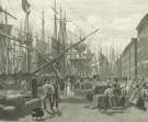 Anne Royalle, an English visitor, wrote in 1826 that the activity on
Pearl Street (wholesalers) was "only a drop in the bucket compared to that
on the wharves and slips, the warehouses, docks, ship yards and auction
stores, on South, Front, and Water Streets." By 1820, New York paid more
duties on goods than did Boston, Philadelphia, Baltimore, and Norfolk and
Savannah combined. Visitors in the 1820s commented that a view of the East
River presented a "forest of masts." Ships lined up along the docks, their
bowsprits and jib booms almost touching the buildings along the waterfront.
Anne Royalle, an English visitor, wrote in 1826 that the activity on
Pearl Street (wholesalers) was "only a drop in the bucket compared to that
on the wharves and slips, the warehouses, docks, ship yards and auction
stores, on South, Front, and Water Streets." By 1820, New York paid more
duties on goods than did Boston, Philadelphia, Baltimore, and Norfolk and
Savannah combined. Visitors in the 1820s commented that a view of the East
River presented a "forest of masts." Ships lined up along the docks, their
bowsprits and jib booms almost touching the buildings along the waterfront.
Ships were loaded and unloaded –before hydraulic or steam-powered
cranes –with pulleys and horses; stevedores then loaded the merchandise
onto small hand trucks or horse-drawn wagons destined for the import-export
warehouses on South Street and nearby side streets.
The following etchings were issued by George Melksham Bourne from his
shop on Broadway near Franklin Street. The prints for his 1831 Views
of New York, etched by various engravers after Charles Burton (American,
b. England, active about 1819–42), are arranged left to right, top
to bottom.
Merchant's Exchange, Wall Str. 1830–31
H. Fossette (American, active about 1831–34)
The Phelps Stokes Collection
 Home for some of New York's wealthiest families after the Revolution,
Wall Street also included several public buildings: City Hall, the temporary
United States Capitol, and the Merchants' Exchange.
Home for some of New York's wealthiest families after the Revolution,
Wall Street also included several public buildings: City Hall, the temporary
United States Capitol, and the Merchants' Exchange.
Public Room, Merchant's Exchange. 1830–31
H. Fossette (American, active about 1831–34)
The Phelps Stokes Collection
Custom House, Wall St. 1830–31
Hatch & Smillie (George W. Hatch and James Smillie; American engraving
firm, active 1831)
The Phelps Stokes Collection
Wall Street's future as the financial center of the country was set
when in 1822 the United States government bought the Verplanck Mansion
on Wall and Broad streets and built on that site the Custom House (later
the Sub-Treasury Building).
United States' Branch Bank, Wall
Street. 1830–31
H. Fossette (American, active about 1831–34)
The Phelps Stokes Collection
 By 1820, this primarily residential neighborhood was changing: finance
and trade –countinghouses, banks, lawyers, insurance companies, and
stockbrokers –spread beyond Pearl Street, the earlier business center,
to Wall Street. In 1825 the National Advocate commented, "almost
every house is a bank or insurance company, and the cellars filled with
brokers instead of potatoes, cabbages, and old wine."
By 1820, this primarily residential neighborhood was changing: finance
and trade –countinghouses, banks, lawyers, insurance companies, and
stockbrokers –spread beyond Pearl Street, the earlier business center,
to Wall Street. In 1825 the National Advocate commented, "almost
every house is a bank or insurance company, and the cellars filled with
brokers instead of potatoes, cabbages, and old wine."
Though the United States' Branch Bank was demolished in 1915 after housing
the assay office for 50 years, the facade was salvaged and is now part
of the American Wing of The Metropolitan Museum of Art.
Bay & Harbour of New York. 1830–31
James Smillie (American, b. Scotland, 1807–1885)
The Phelps Stokes Collection
 The Battery to the tip of Manhattan remained an oasis of beauty and
calm. As early as 1785 there was pressure to landscape the Battery as a
place for walking and viewing the harbor. Philip Hone, the Mayor of New
York in 1825, wrote in his diary about the park, "A more delightful scene
can nowhere be found." Mrs. Frances Trollope enthused, "no city could boast
. . . a public promenade . . . more beautiful." The actress Fanny Kemble
observed of the harbor that it "must be the most beautiful in the world," with
the sailing ships, "glancing like graceful sea-birds, through their native
element."
The Battery to the tip of Manhattan remained an oasis of beauty and
calm. As early as 1785 there was pressure to landscape the Battery as a
place for walking and viewing the harbor. Philip Hone, the Mayor of New
York in 1825, wrote in his diary about the park, "A more delightful scene
can nowhere be found." Mrs. Frances Trollope enthused, "no city could boast
. . . a public promenade . . . more beautiful." The actress Fanny Kemble
observed of the harbor that it "must be the most beautiful in the world," with
the sailing ships, "glancing like graceful sea-birds, through their native
element."
Junction of Broadway & the Bowery.
1830–31
James Smillie (American, b. Scotland, 1807–1885)
The Phelps Stokes Collection
 The rocky outcroppings and hills of Manhattan had to be removed and
leveled as the city progressed north. In 1807, Broadway was "regulated" from
Astor Place to 23rd Street, and in 1815 the city designated part of that
area as a public park. This future park, Union Square, is in 1830 a very
nondescript intersection of Broadway and the Bowery (now called Fourth
Avenue for several blocks below the square).
The rocky outcroppings and hills of Manhattan had to be removed and
leveled as the city progressed north. In 1807, Broadway was "regulated" from
Astor Place to 23rd Street, and in 1815 the city designated part of that
area as a public park. This future park, Union Square, is in 1830 a very
nondescript intersection of Broadway and the Bowery (now called Fourth
Avenue for several blocks below the square).
City Hotel, Trinity & Grace Churches Broadway. 1831–34
Archibald L. Dick (American, b. Scotland, about 1805–about 1865)
after James H. Dakin (American, b. 1806)
Etching and engraving, from Fay, Views in New-York and Its Environs,
published by Peabody and Company
The Phelps Stokes Collection
City Hotel, located on Broadway between Thames and Cedar, was probably
the first building in the United States that was designed specifically
as a hotel (1794), the first of numerous hotels that were constructed along
Broadway in the 19th century.
The Trinity Church in this view is the second Trinity on this site on
Broadway and Wall; it was built between 1788 and 1790, the first Trinity
having burned in 1776 during the British occupation. The 200-foot spire
was a favorite spot from which to view the city in the early 19th century.
City Hall and Park Row. 1830
John William Hill (American, b. England, 1812–1879)
Watercolor
The Phelps Stokes Collection
 John William Hill was only 18 years old when he recorded this view
of City Hall and its lovely park, at this time surrounded by an ornamental
fence. To the right is Park Row, with elegant shops and buildings, including
Park Theatre, which was the leading theatre in New York at the beginning
of the 19th century (in this view, the steeple of Brick Presbyterian Church
looms over it). A barrel wagon for distributing water, one of the few sources
of potable water, is passing in front of the park. A ready source of water
was important not only for drinking, but also for extinguishing fires;
in the foreground two fire engines, manned by volunteers, head to a fire;
one racing wagon has run over a pedestrian. The city relied on volunteers
until a professional fire department was established in 1865.
John William Hill was only 18 years old when he recorded this view
of City Hall and its lovely park, at this time surrounded by an ornamental
fence. To the right is Park Row, with elegant shops and buildings, including
Park Theatre, which was the leading theatre in New York at the beginning
of the 19th century (in this view, the steeple of Brick Presbyterian Church
looms over it). A barrel wagon for distributing water, one of the few sources
of potable water, is passing in front of the park. A ready source of water
was important not only for drinking, but also for extinguishing fires;
in the foreground two fire engines, manned by volunteers, head to a fire;
one racing wagon has run over a pedestrian. The city relied on volunteers
until a professional fire department was established in 1865.
Broadway and Trinity Church. 1830
John William Hill (American, b. England, 1812–1879)
Watercolor
The Phelps Stokes Collection
 Anne Royale, visiting from England in 1826, wrote that Broadway was
a favorite strolling place for the "fashionable, the gay, the idle." A
central axis of the city, Broadway grew quickly, encouraging the growth
of the rest of the city in its wake. At the end of the 18th century, Broadway
at Chambers was still considered "country," but after 1800, when the hill
at Duane Street was leveled, the city's edge quickly moved north. In 1805
Broadway was "regularized" up to Prince Street; the following year, to
Great Jones, and in 1807 it ended in a farmer's picket fence at Astor Place.
Anne Royale, visiting from England in 1826, wrote that Broadway was
a favorite strolling place for the "fashionable, the gay, the idle." A
central axis of the city, Broadway grew quickly, encouraging the growth
of the rest of the city in its wake. At the end of the 18th century, Broadway
at Chambers was still considered "country," but after 1800, when the hill
at Duane Street was leveled, the city's edge quickly moved north. In 1805
Broadway was "regularized" up to Prince Street; the following year, to
Great Jones, and in 1807 it ended in a farmer's picket fence at Astor Place.
By the time John William Hill, looking south from Liberty Street, recorded
this view of Broadway and Trinity Church with Grace Church in the distance,
private residences south of Trinity were being replaced by banks, countinghouses,
and dry goods warehouses (except around Bowling Green); the finest shops,
hotels, and theatres were prospering between Trinity and City Hall. Many
affluent New Yorkers were moving uptown to Bond and Bleecker streets, Park
Place and St. John's Park, separating themselves from "trade" and from
growing numbers of immigrants, who were settling in the Five Points District
(Foley Square), in what would become the Lower East Side, and near the
docks along the East and Hudson rivers.
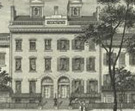
New York Bank House Hammond Street.
1830
John William Hill (American, b. England, 1812–1879)
Watercolor
The Phelps Stokes Collection
 Since the late 18th century, Greenwich Village had served as a safe
haven when outbreaks of yellow fever and cholera periodically threatened
New York. In 1805 an English visitor wrote, "Those who cannot go far, on
account of business, removed to Greenwich, a small village situated on
the border of the Hudson River, about two or three miles from town."
Since the late 18th century, Greenwich Village had served as a safe
haven when outbreaks of yellow fever and cholera periodically threatened
New York. In 1805 an English visitor wrote, "Those who cannot go far, on
account of business, removed to Greenwich, a small village situated on
the border of the Hudson River, about two or three miles from town."
This house was occupied by the Bank of New York during the yellow fever
epidemics of 1799, 1803, 1805, and 1822. During this last outbreak, hundreds
of wooden houses were constructed in the Village to accommodate New Yorkers
fleeing lower Manhattan. Many decided to remain after the danger was over.
By 1825, the Commercial Advertiser announced, "Greenwich is now
no longer a country village. Such has been the growth of our city that
the building of one block more will completely connect the two places;
and in three years' time, at the rate buildings have been erected the last
season, Greenwich will be known only as a part of the city, and the suburbs
will be beyond that." The prediction was accurate. Between 1825 and 1840
the population in the Village quadrupled as blocks of row houses were built
to accommodate merchants and tradesmen. James Fenimore Cooper praised the
Village as a place "where middle-class New Yorkers could live comfortably." Greenwich
Village was also known as the "American ward," where residents were largely
native-born.
Residence of Philip Hone and American
Hotel, Broadway. 1831
Barnard & Dick (William S. Barnard and Archibald L. Dick; American engraving
firm, active about 1831)
after James H. Dakin (American, b. 1806)
Etching and engraving, from Fay, Views in New-York and Its Environs,
published by Peabody and Company
The Phelps Stokes Collection
 Philip Hone, a successful businessman as well as a Mayor of New York,
purchased his home at 235 Broadway, opposite City Hall, in 1821. His neighbors
to the north included the American Hotel, which opened in 1827, and Peabody & Company,
the publishers of this and the following etching from Theodore S. Fay's Views
in New-York and Its Environs. Shortly after this series of prints was
issued, Hone's neighbor John Jacob Astor tore down his house at 223 Broadway
to make way for a hotel, the Astor House. Construction noise and the increasing
street hubbub as "trade" moved north up Broadway (and the prospect of a
healthy profit) enticed Hone to sell his home to the owner of the American
Hotel. Hone wrote, "I shall leave this delightful house with feelings of
deep regret. . . . I have turned myself out of doors, but $60,000 is a
great deal of money." Fortunes were indeed being made from the rising prices
of real estate. Hone paid $21,000 for his property in 1821 and sold it
for a $39,000 profit 16 years later. Today, the Woolworth Building stands
on this site.
Philip Hone, a successful businessman as well as a Mayor of New York,
purchased his home at 235 Broadway, opposite City Hall, in 1821. His neighbors
to the north included the American Hotel, which opened in 1827, and Peabody & Company,
the publishers of this and the following etching from Theodore S. Fay's Views
in New-York and Its Environs. Shortly after this series of prints was
issued, Hone's neighbor John Jacob Astor tore down his house at 223 Broadway
to make way for a hotel, the Astor House. Construction noise and the increasing
street hubbub as "trade" moved north up Broadway (and the prospect of a
healthy profit) enticed Hone to sell his home to the owner of the American
Hotel. Hone wrote, "I shall leave this delightful house with feelings of
deep regret. . . . I have turned myself out of doors, but $60,000 is a
great deal of money." Fortunes were indeed being made from the rising prices
of real estate. Hone paid $21,000 for his property in 1821 and sold it
for a $39,000 profit 16 years later. Today, the Woolworth Building stands
on this site.
LeRoy Place and Shot Tower –East
River. 1831
Archibald L. Dick (American, b. Scotland, about 1805–about 1865)
after Alexander Jackson Davis (American, 1803–1892) and Lundie (American,
19th century?)
Etching and engraving, from Fay, Views in New-York and Its Environs,
published by Peabody and Co.
The Phelps Stokes Collection
 As the residential streets of lower Broadway were taken over by "trade," the
well-to-do moved uptown, ahead of the shops, hotels, offices, and warehouses.
The regularized and wide thoroughfares of Bleecker, Bond, and Great Jones
streets were among the choicest of residential areas in the late 1820s,
1830s, and into the 1840s. Philip Hone, who purchased a lot on the southeast
corner of Broadway and Great Jones Street after selling his home at 223
Broadway, wrote in his diary, "Almost everybody downtown is in the same
predicament. We are tempted with prices so exorbitantly high that none
can resist, and the old downtown burgomasters, who have fixed to one spot
all their lives, will be seen during the next Summer in flocks, marching
reluctantly north."
As the residential streets of lower Broadway were taken over by "trade," the
well-to-do moved uptown, ahead of the shops, hotels, offices, and warehouses.
The regularized and wide thoroughfares of Bleecker, Bond, and Great Jones
streets were among the choicest of residential areas in the late 1820s,
1830s, and into the 1840s. Philip Hone, who purchased a lot on the southeast
corner of Broadway and Great Jones Street after selling his home at 223
Broadway, wrote in his diary, "Almost everybody downtown is in the same
predicament. We are tempted with prices so exorbitantly high that none
can resist, and the old downtown burgomasters, who have fixed to one spot
all their lives, will be seen during the next Summer in flocks, marching
reluctantly north."
LeRoy Place, on the site of present-day Washington Square Village, presented
a handsome facade on Bleecker between Mercer and Greene, set back 10 feet
from the street, with a procession of identical facades, save for the center
two, which were taller and projected out a few feet. Individual homes sold
for $11,000 and $12,000. However, when trade crossed Bleecker shortly after
1851 and 1852, it was a death knell for this fashionable neighborhood.
By 1853, the Builder observed that "Bond and Bleecker Streets, that were
then the ultima thule of aristocracy, are now but plebian streets." The
shot tower, where ammunition was manufactured, was erected in 1823 on the
East River, between 53rd and 54th streets.
La Grange Terrace –La Fayette
Place. 1831–34
Anonymous, after James H. Dakin (American, b. 1806)
Etching and engraving, from The New York Visitor, 1842 (first published
as part of The Peabody Views)
Eno Collection
 The Knickerbocker reported that La Grange Terrace, also known
as Colonnade Row (1833), was "universally allowed to be unequaled for grandeur
and effect." The nine adjoining Greek Revival houses, under a single, grand,
unified facade, were "the most imposing and magnificent in the city," and
sold for between $25,000 and $30,000. Some of New York's finest families
lived here, including Franklin H. Delano, grandfather of Franklin Delano
Roosevelt, and David Gardner, whose daughter Julia married President John
Tyler.
The Knickerbocker reported that La Grange Terrace, also known
as Colonnade Row (1833), was "universally allowed to be unequaled for grandeur
and effect." The nine adjoining Greek Revival houses, under a single, grand,
unified facade, were "the most imposing and magnificent in the city," and
sold for between $25,000 and $30,000. Some of New York's finest families
lived here, including Franklin H. Delano, grandfather of Franklin Delano
Roosevelt, and David Gardner, whose daughter Julia married President John
Tyler.
La Grange Terrace didn't initially fall to trade, but the neighborhood
gradually declined in the 1850s and 1860s as private homes became boardinghouses,
and tenements were built on the other side of Bowery. Eventually patrician
row houses were torn down for sweatshop lofts and warehouses. A small portion
of the two-story colonnade (four houses of the original nine), which ran
the full length of the facade, still exists on the west side of Lafayette,
just south of Astor Place. The stone work, now battered and shabby, was
done by inmates at Sing Sing.
View of St. John's Chapel, from the Park. 1829
William D. Smith (American, active 1822–after 1860)
after Alexander Jackson Davis (American, 1803–1892)
Etching and engraving, from The New-York Mirror
Print Collection
In 1803, Trinity Church laid out St. John's Park, a parcel of land owned
by the church on Varick, Beach (now Ericsson Place), Hudson, and Laight;
the centerpiece was St. John's Chapel on Varick. Initially, the area was
slow to develop (the church first tried unsuccessfully to lease the house
lots), but by the mid-1820s the property was considered "the fairest interior
portion of this city"; when the New-York Mirror published this
view, Hudson Square, as it was also known, was one of the loveliest residential
areas in the city. The church deeded the park to the owners of the 64 surrounding
housing lots, and they fenced in this private oasis for the sum of $25,000.
The fence could not keep out the noise, hubbub, and crime from the encroaching
warehouse district and the traffic from the nearby waterfront, and when
the Hudson River Railroad in 1851 ran tracks along Hudson Street, the sanctuary
of the bucolic neighborhood was irreversibly shattered. In 1866, Commodore
Vanderbilt bought the park as the site for the New York Central Railroad
freight depot; the chapel was torn down in 1918–19 for subway construction
and to widen Varick Street.
Columbia College, New-York. 1828
Vistus Balch (American, 1799–1884)
after Alexander Jackson Davis (American, 1803–1892)
Etching and engraving, from The New-York Mirror, and Ladies Literary Gazette
Eno Collection
 Park Place and the neighborhood around Chambers Street, west of City
Hall, offered another refuge for the well-to-do wishing to escape the noise
and bustle of lower Broadway. When the Baroness Hyde de Neuville and Milbert
recorded these streets earlier in the century, this was a middle-class
enclave. But by the late 1820s, Park Place and the neighboring streets
had taken on the patina of the fashionable areas around the Battery and
Trinity. Columbia College (on Barclay, Church, Murray, and College Place
[West Broadway]) contributed to the éclat of the neighborhood, but
when the college moved uptown in 1857, it was just one more factor in the
decline of the area. In the 1840s, the vicinity of Greenwich Street and
College Place became a ghetto for the city's blacks (others lived in the
Five Points District; many later moved to an enclave south of Washington
Square Park) and immigrants (mostly German and Irish). Poor boardinghouses
soon became slums. When real estate prices sharply dropped (hastened by
the city's decision to raise and widen streets in the area, perhaps in
collusion with real estate interests and merchants), the drygoods merchants
and real estate speculators took advantage of the opportunity. By the mid-1850s,
the old Columbia campus was surrounded by warehouses, and drygoods firms
had taken over the Park Place district.
Park Place and the neighborhood around Chambers Street, west of City
Hall, offered another refuge for the well-to-do wishing to escape the noise
and bustle of lower Broadway. When the Baroness Hyde de Neuville and Milbert
recorded these streets earlier in the century, this was a middle-class
enclave. But by the late 1820s, Park Place and the neighboring streets
had taken on the patina of the fashionable areas around the Battery and
Trinity. Columbia College (on Barclay, Church, Murray, and College Place
[West Broadway]) contributed to the éclat of the neighborhood, but
when the college moved uptown in 1857, it was just one more factor in the
decline of the area. In the 1840s, the vicinity of Greenwich Street and
College Place became a ghetto for the city's blacks (others lived in the
Five Points District; many later moved to an enclave south of Washington
Square Park) and immigrants (mostly German and Irish). Poor boardinghouses
soon became slums. When real estate prices sharply dropped (hastened by
the city's decision to raise and widen streets in the area, perhaps in
collusion with real estate interests and merchants), the drygoods merchants
and real estate speculators took advantage of the opportunity. By the mid-1850s,
the old Columbia campus was surrounded by warehouses, and drygoods firms
had taken over the Park Place district.
Erie Canal
Although New York in 1825 already handled almost half the nation's imports
and fully a third of its exports, this remarkable statistic seemed modest
when compared to the level of commercial activity possible once the Erie
Canal opened in October of that year. Although all the cities along its
route benefited from the canal (within ten years, upstate cities along
the canal had grown by an average of 300 percent), New York reaped the
greatest rewards as the middleman for goods produced across America and
Europe. Shipping costs dropped dramatically, and even more imports and
exports now passed through New York.
A View of the . . . Fire Works Exhibited
in the N.Y. City Hall. 1825
John Francis Eugene Prud'homme (American, 1800–1892)
after R. Willcox (possibly American, 19th century)
Engraving, from Colden, Memoir . . . , 1826
Print Collection
The celebrations attendant upon the opening of the Erie Canal on October
25, 1825, included a fireworks display outside City Hall.
Grand Canal Celebration. 1825
Anthony Imbert (American, b. France, active about 1825–34)
after Archibald Robertson (American, b. Scotland, 1765–1835)
Lithograph, from Colden, Memoir . . . . . ., 1826
The Phelps Stokes Collection
 Folded into Cadwallader D. Colden's account of the building of the
Erie Canal is this lithograph recording the fleet lining up for the Grand
Canal Celebration in New York Harbor. On the far right is the U.S. Revenue
Office at Whitehall Slip and Pier 1 on the East River side of the Battery;
next to it is the base of the old "churn" flagstaff, and finally Castle
Garden, which recently had been renamed and converted into a theatre.
Folded into Cadwallader D. Colden's account of the building of the
Erie Canal is this lithograph recording the fleet lining up for the Grand
Canal Celebration in New York Harbor. On the far right is the U.S. Revenue
Office at Whitehall Slip and Pier 1 on the East River side of the Battery;
next to it is the base of the old "churn" flagstaff, and finally Castle
Garden, which recently had been renamed and converted into a theatre.
Broadway, New-York. Shewing Each
Building from . . . Canal Street to Beyond Niblo's Garden. About 1834
John Hill (American, b. England, 1770–1850)
after Thomas Horner (American, b. England, active 1830s)
Colored aquatint and etching, with additional hand-coloring, 1836
The Phelps Stokes Collection
 By the mid-1830s, the city extended three miles north of the Battery,
ending in pastures beyond Houston, as trade took over more and more of
downtown. At about this date, Thomas Horner looked up Broadway toward Prince
Street from a vantage point just below Canal and recorded the stagecoaches
(regular omnibus service on Broadway began in 1827) and private carriages
that crisscrossed the 80-foot-wide street, and the shops that lined the
bustling thoroughfare (note the subtly self-promoting sign for Joseph Stanley,
publisher of this print and importer of books, prints, and stationery).
The shops are framed by wooden pillars, often covered with placards advertising
the shops' wares, set along the outer edge of the pavement; from these
were suspended awnings that shaded the sidewalk.
By the mid-1830s, the city extended three miles north of the Battery,
ending in pastures beyond Houston, as trade took over more and more of
downtown. At about this date, Thomas Horner looked up Broadway toward Prince
Street from a vantage point just below Canal and recorded the stagecoaches
(regular omnibus service on Broadway began in 1827) and private carriages
that crisscrossed the 80-foot-wide street, and the shops that lined the
bustling thoroughfare (note the subtly self-promoting sign for Joseph Stanley,
publisher of this print and importer of books, prints, and stationery).
The shops are framed by wooden pillars, often covered with placards advertising
the shops' wares, set along the outer edge of the pavement; from these
were suspended awnings that shaded the sidewalk.
Though traffic on the street and sidewalk was often daunting –a
Swedish visitor commented that pedestrians on Broadway had "need of a pair
of eyes in the back of the neck and an eye at each ear, in order to escape
being run over or trampled down [by the] surging throng" –you could
always retire to a retreat like Niblo's Garden on Broadway and Prince Street,
just barely visible in the distance on the right side of Broadway, pinpointed
by a flagpole. Niblo's establishment, which included a theatre, hotel,
and garden with walks and flowers, was considered by some to be the best
entertainment spot in the city.
The Great Fire of 1835
On December 16, 1835, a fire broke out at Comstock and Adams's drygoods
warehouse at Pearl and Hanover streets and spread quickly through the crowded
neighborhood. The night was so cold that water froze in the pipes and leather
hoses, hampering the firefighters. By the next day, nearly 700 buildings –some
1,000 mercantile houses –on 17 blocks along the East River were destroyed,
losses that were almost total when many insurance companies went bankrupt.
But as Philip Hone noted in his diary, the empty lots quickly increased
in value and the fire's devastation only sped the transition from private
residences to business offices and warehouses; within a year, the district
was "rebuilt with more splendor than before. . . ."
The Merchants' Exchange, N.Y. 1831
Fenner Sears & Co. (British engraving firm, active about 1825–46)
after Charles Burton (American, b. England, active about 1819–42)
Etching and engraving, from Hinton's History and Topography of the United
States, 1832
Eno Collection
One of the casualties of the fire was the Merchants' Exchange.
Hanington's Dioramic Representation of the Great Fire in New York
. . . at the American Museum. 1835
H. Sewell (American, active mid-1830s)
Colored lithograph
Print Collection, Norrie Fund
According to this lithograph by H. Sewell, the American Museum on the
corner of Broadway and Ann Street exhibited in 1836 a diorama of the Great
Fire, featuring the dramatic destruction of the Merchants' Exchange. The
artists, William J. Hanington and his brother, Henry, produced many moving
dioramas, which were shown in New York, Philadelphia, Boston, and other
cities from 1832 to 1856.
New York, from Brooklyn Heights.
About 1836
William James Bennett (American, b. England, 1787–1844)
after John William Hill (American, b. England, 1812–1879)
Colored aquatint and etching, 1837
The Phelps Stokes Collection
 Between the time that Thomas Horner sketched Broadway and John William
Hill recorded from a Brooklyn rooftop on Columbia Heights this view of
New York from Wall to Canal streets, New York had been devastated by the
Great Fire of 1835. The conflagration, which cleared an area between Wall
and Broad streets and the East River, allowed merchants to replace the
ruins of the often old-fashioned residential buildings with new offices
and commercial warehouses, and within a month of the fire, Philip Hone
(former Mayor of New York and avid diarist) wrote that the land was bringing "enormous
prices, greater than they would have brought before the fire, when covered
with valuable buildings." By the time of Hill's view, magnificently translated
into aquatint by William James Bennett, "the whole is rebuilt with more
splendor than before . . . to the honor of the merchants and as an evidence
of the prosperity of the city." The construction of the Merchants' Exchange,
the domed building on the far left (complete in Hill's rendition, though
in actuality still under construction), hastened Wall Street's transition
from a residential to a business neighborhood.
Between the time that Thomas Horner sketched Broadway and John William
Hill recorded from a Brooklyn rooftop on Columbia Heights this view of
New York from Wall to Canal streets, New York had been devastated by the
Great Fire of 1835. The conflagration, which cleared an area between Wall
and Broad streets and the East River, allowed merchants to replace the
ruins of the often old-fashioned residential buildings with new offices
and commercial warehouses, and within a month of the fire, Philip Hone
(former Mayor of New York and avid diarist) wrote that the land was bringing "enormous
prices, greater than they would have brought before the fire, when covered
with valuable buildings." By the time of Hill's view, magnificently translated
into aquatint by William James Bennett, "the whole is rebuilt with more
splendor than before . . . to the honor of the merchants and as an evidence
of the prosperity of the city." The construction of the Merchants' Exchange,
the domed building on the far left (complete in Hill's rendition, though
in actuality still under construction), hastened Wall Street's transition
from a residential to a business neighborhood.
Hill's panorama identifies other landmarks, including the impressive
white building to the left of center, Holt's Hotel, which opened in 1833.
By 1836 one newspaper boasted: "What charming private residences! What
majestic city halls, courts, colleges, libraries, academies. . . . What
fine rows of buildings! What streets and squares! What parks, theaters,
opera houses, arcades, and promenades! Will not this become one of the
most wealthy, populous, and splendid cities of the globe?"